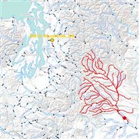
 On a hike through the mountains in the Pacific Northwest, you’ll often cross some streams flowing down the mountain. Where do they start? How do they make their way to the ocean? There’s a tool from nationalatlas.gov that can answer these questions. You click on any point in a river and trace it upstream and downstream. It’s neat to see how differently a raindrop could flow if it lands just a couple hundred yards east or west. One is a quick trip to the Puget sound while another might be a more roundabout trip into the Columbia River and then out into the Pacific on the border between Washington and Oregon.
Studio711.com – Ben Martens
Just trying to get through life without looking stupid, so far it's not going very well.
