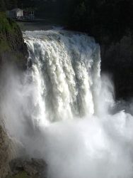
After my abysmal physical performance on Friday, I was pretty down on myself so I decided I need to get back on the trail and prove I wasn't a tub of lard. After church on Sunday, I drove to exit 34 and found Twin Falls State Park. The trail is not very strenuous (2.2 miles each way with 1300 cumulative elevation gain) so I set a quick pace and didn't take any rest stops. That was the plan anyway, but I did end up stopping at two points along the trail to view the amazing waterfall. It's not as big as Snoqualmie, but the hike up there makes it much much less crowded. If you click the image on the right, you'll see a large stitched photo of the full falls. It's hard to get a perspective from a picture like this, but the falls are 135ft high and about 30ft wide.
Our book of trails says this is a 2-4 hour hike, but I pounded it out in 1 hour and 23 minutes, and according to the GPS, I was stopped for 11 minutes of that time. As I came back across the bridge over the falls which is 1.2 miles from the trailhead, I crossed paths with the two groups that had left the trailhead at the same time as me. In the time it took them to go 1.2 miles, I had gone 2.2 miles up to the top and then 1 mile back down to that bridge. That brought a smile to my face.
The top of the trail connects with the Iron Horse Trail. That's the old railroad grade that goes all the way up to Snoqualmie Pass and includes a 2.2 mile long tunnel under the ski area. Tim and I have plans to ride our bikes down that one of these days so it was nice to see what the trail actually looked like.
This was the first time that I have ever hiked by myself. It was a great way to recharge my batteries, clear out a head that has been consumed with a lot of thoughts lately, and get in a good workout. After getting home, I proceeded to spend the rest of the afternoon on the couch watching NASCAR, but somehow I didn't feel too lazy which made it even better.
More pictures are available in the photo gallery under Outdoors > Twin Falls.